A friend sent me to this map. If you're interested in the origins of country names, it's pretty cool!
Map link
Thanks to the Canadian Government's commercials of years past, I already knew that we're named for an Aboriginal name for "village".
For me, I'd like to go back to the land of wood and water, it's awesome! (i.e. Jamaica)
Showing posts with label Maps. Show all posts
Showing posts with label Maps. Show all posts
Friday, February 4, 2011
Thursday, January 20, 2011
Mappily amused
I will freely admit, I'm an addict.
I love maps. I know, of all the things, I pick inanimate depictions of the world. But it's true, I just really love to sit with a map and explore in my mind. It's interesting for areas that I don't know. It's a trip down memory lane for areas that I have travelled through.
Google Earth. It's a terrible, terrible program. For me it's like placing a 40 pounder in front of an alcoholic and saying "Have all you want, there's more in the back." I was using it to map out the locations of a bunch of bridges that I have to inspect later this year. Once that was accomplished, I zoomed in and looked at all of the bridges, where the resolution allowed that of course. And then the bender started. I spent altogether far too much time wandering around the two provinces that I've lived in - British Columbia and Alberta - just exploring, following roads to their destination, recalling driving through scenery, seeing a glacier and going "Aha! Source for the Athabasca River!"
I had to close the software, just to keep from being tempted. Sure, it was helpful to visualize my work plan for about 4 weeks of work this summer. Gallivanting around central and southern Alberta, coming within 10 km of Montana (note to self, get a photo of Mount Poe), going to a several bridges I've inspected before, only this time in depth. Yeah, I had a great trip in my own mind.
It doesn't even have to be topo maps or road maps. Give me maps with demographic information and I'll peruse that, mentally correlating information with locations and seeing interesting... stuff. I even went cruising around the Cayman Trench earlier today... underwater, it was kind of different. I can point to where my enjoyment of maps started. It was those nefarious people in the Royal Canadian Air Cadets teaching me how to read topographic maps. Yeah, yet another part of my life interests that is influenced by Cadets :-)
Have I mentioned that maps are entertaining? And in that sense, I'll finish off with a fun map for the rest of you, who aren't as mappily amused as me. The evil geniuses at XKCD have done another one of their comics, this time showing the world... well, I'll let the comic explain it better than I can.
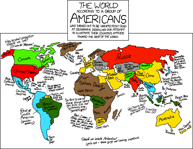
Click-through to view the page, and of course, as with ALL XKCD comics, check out the mouse-over text! (on their page, not this one). I do enjoy the Boxing Day quip...
I love maps. I know, of all the things, I pick inanimate depictions of the world. But it's true, I just really love to sit with a map and explore in my mind. It's interesting for areas that I don't know. It's a trip down memory lane for areas that I have travelled through.
Google Earth. It's a terrible, terrible program. For me it's like placing a 40 pounder in front of an alcoholic and saying "Have all you want, there's more in the back." I was using it to map out the locations of a bunch of bridges that I have to inspect later this year. Once that was accomplished, I zoomed in and looked at all of the bridges, where the resolution allowed that of course. And then the bender started. I spent altogether far too much time wandering around the two provinces that I've lived in - British Columbia and Alberta - just exploring, following roads to their destination, recalling driving through scenery, seeing a glacier and going "Aha! Source for the Athabasca River!"
I had to close the software, just to keep from being tempted. Sure, it was helpful to visualize my work plan for about 4 weeks of work this summer. Gallivanting around central and southern Alberta, coming within 10 km of Montana (note to self, get a photo of Mount Poe), going to a several bridges I've inspected before, only this time in depth. Yeah, I had a great trip in my own mind.
It doesn't even have to be topo maps or road maps. Give me maps with demographic information and I'll peruse that, mentally correlating information with locations and seeing interesting... stuff. I even went cruising around the Cayman Trench earlier today... underwater, it was kind of different. I can point to where my enjoyment of maps started. It was those nefarious people in the Royal Canadian Air Cadets teaching me how to read topographic maps. Yeah, yet another part of my life interests that is influenced by Cadets :-)
Have I mentioned that maps are entertaining? And in that sense, I'll finish off with a fun map for the rest of you, who aren't as mappily amused as me. The evil geniuses at XKCD have done another one of their comics, this time showing the world... well, I'll let the comic explain it better than I can.
Click-through to view the page, and of course, as with ALL XKCD comics, check out the mouse-over text! (on their page, not this one). I do enjoy the Boxing Day quip...
Subscribe to:
Comments (Atom)


